 Skip to:
  Lyndenlea
Milestones
 Two drunks were
walking along a country road one day...
Two drunks were
walking along a country road one day...
...when they passed a churchyard. Having nothing better to do they decided to stop and read some of the gravestones. Suddenly, one of them swore rather loudly. "There must be something in the water around these parts," he said to his friend. "This chappy here lived to be one hundred and twenty!" "Blimey, that's impressive," his friend replied. "What was his name?" Bending down he slowly read the rest of the inscription: "Miles, from London..."
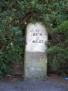
As you might already have guessed from the photograph (and the best joke I know on the subject – sorry), this part of my website is all about Milestones – specifically, roadside milestones that indicate the distance to cities, towns and other landmarks. Since the middle of the 18th Century (and in just over 100 cases, since Roman times) many roadsides in the United Kingdom have been adorned by these and similar waymarkers, but time and countless other factors have seen a considerable number lost. Consequently I decided to research and record some of those that remain in my local area around Bristol and Bath.
The milestone in the photograph on this page is the first one that I ever recorded as part of this research project back in July 2007. It stands at the side of Rodway Hill Road in Mangotsfield and forms part of an almost complete fourteen-mile route between Hambrook and Bath. This website now contains details of 97 milestones on 30 different routes leading to Bath, Bristol, Chippenham and Chipping Sodbury, and I still have plenty more to seek out and record as time and circumstances allow, all of which I will add to this website as my research progresses.
Related links
During my research into milestones, both locally and more generally, I found a number of websites invaluable. Here they are, along with a few others on similar topics surrounding roads and their history.
- Alan Godfrey Maps – Reprints of old Ordnance Survey maps
- More than 3,500 titles have been issued in this major series of reprints of old Ordnance Survey maps of towns throughout Britain and Ireland. They cover towns in great detail showing individual houses, churches, railways and tramlines, and even minutiae such as dockside mooring posts, signal posts, fountains, pathways, sheds, and – most importantly in this context – milestones. Buy online or in many good bookshops.
- The Milestone Society
- Founded in May 2001, The Milestone Society aims to identify, record, research and interpret for the public benefit the milestones and other waymarkers of the British Isles. They have a network of County Representatives who help to facilitate the collection of data on milestones and raise local awareness on this aspect of our national heritage at the County level.
- National Library of Scotland – Map Images
- Early Ordnance Survey maps are an excellent resource for finding out where milestones are supposed to be. Although the locations of many milestones continue to be marked accurately on modern maps, very often a milestone marked on the map is nowhere to be found, or I'll find a milestone on the ground that isn't marked on the map. This NLS resource offers free online access to maps dating from 1560 to 1970 and coverage includes Great Britain, Ireland and more.
- SABRE – The Society for All British and Irish Road Enthusiasts
- A group of enthusiasts and professionals interested in the history, design, geography and structure of the British and Irish road network. They exist as a forum for ideas and opinions, and as a hub for information for better understanding of the road network in the UK and Ireland and its history. Check out their Links and Member Sites pages for lots more on this surprisingly fascinating subject.
- Turnpike Roads in England & Wales
- A hub for information on the history of Turnpike Trusts, roads, tollhouses and milestones, and the travellers who used these roads.